Here's a report on the 4x4 trip we took down the Green Valley Powerline Trail on Saturday November 18, 1995. Participants included Bob Peterson and Bobby and Anna in Bob's 87 Chevy Suburban (lifted, rear locker, 33-inch tires), John Hill in his 94 Chevy K2500 extended cab (31-inch tires, XD9000 winch), and John Waack in his Suzuki Samurai (front and rear lockers, 33-inch tires, rock lobster gears).
We'd like to thank Doug Officer for recommending this trail which is loaded with fun hill climbs. The trail was passable with my almost stock Chevrolet, but there were plenty of climbing challenges for those with lockers on the side hills. We picked up the trail where the powerline crosses the Mt. Hopkins road and followed it south for 10 miles or so. We all got some exercise from a half hour of digging and moving rocks to fill in a rut where the trail had washed out.
To reach the north end of the trail: Use I-19 exit 56, Canoa, and follow the frontage road south; turn east on Elephant Head Road following the signs to Whipple Observatory. Turn south where the road crosses under the powerline. If you get to the observatory base camp, you went too far.
John Hill in "The River .... runs through it", John Waack in "Over Easy" and Bob Peterson with Anna and Bobby in "Willy" ran the Green Valley Powerline trail (south from Mt. Hopkins Rd.) in the morning on Saturday, February 3, 1996. As previously reported, this is a fairly easy trail with a couple fun hill climbs (difficulty=3). The weather was ideal for wheelin' --- not too warm, not too cold and enough rain earlier in the week to suppress the road dust. Bob and John are leading a Tucson Rough Riders trip on the Powerline trail in March, so this trip was to get all the trail descriptions and mileages correct.
Then in the afternoon we cruised cross-country on some ranch roads to Bull Springs Road which takes us around the south side of Mt. Hopkins. We went up Josephine Canyon for a little more challenge. An unmaintained Forest Service road goes up out of the canyon and comes out at km 13 on the MMT road. This is the brushiest trail I've ever been on --- if it was any brushier, it wouldn't be a trail. We'll rate this one a 4 for it's combination of brush avoidance and off-camber hills. Bob's Suburban had previously done this road in stock condition, but this one isn't for the beginner. The views of Mt. Wrightson and Josephine Canyon and Mexico were quite spectacular although it was getting pretty cloudy at the end of the day. All the trucks, especially the full-size Chevys got some new pinstriping (now a nice uniform patina of scratches), but not much other damage. Even all the antennas and mirrors survived the trip. The only casualty was my camera: it got slammed into a rock (lens first) at high velocity when I slipped while climbing a rocky hill (on foot). No damage to me, but little plastic camera parts went flying everywhere and some more are rattling around on the inside. (There won't be any photos of Saturday's adventure.)
Well, you missed the Free Willy II expedition. John and I scouted the powerline trail again 2 weeks ago and found some killer hill climbs farther south. We had a small turnout for our Rough Rider run (2 March 96), but that was because we didn't have time to properly advertise it. When word gets out, I think there will be alot of people wanting to run it. Besides me and John, 2 Jeep Wranglers showed up, one lifted with locker and limited slip, and one stock. Everything was going fine until we hit the big hill that gave us problems when the 3 of us ran it, remember it took 3-4 tries to get up it. Willy made it first try, but the stock Wrangler after a couple of tries needed a tow, I backed down and straped the jeep to Willy, and tried to pull him up, I got Willy bouncing pretty badly, and POP! goes the axle. Now I'm stuck in the trail with everyone behind me, well John and I cruised the wash and found a trail out that got us above Willy, with John's winch and Willy with one front wheel and one rear wheel pulling we got Willy up on flat land. As we were all looking at Willy, I said 'well the price of wheelin'', the guy in the Wrangler, this was his first time out, say's, what do you mean 'the price of wheelin'', we told him that wheelin' isn't a cheap hobby, and expect to spend money on the the fun you have breaking things on your 4x4. I called Amy on the cell phone and she picked up a new axle and bearing seal. We continued the trail south, the stock wrangler got close to tipping over once, the drivers wife lets out a scream that made me jump. The trail south has a couple of class 4 climbs that gave us a good challange, winching required. We came out near the old Mission by the freeway. On Sunday John and I returned with the new axle and had Willy up and running in about 3 hours, but with practice I bet we could do it in 2.5 hours. (Bob fails to mentions the thrills of working on a truck parked near a high tension power line.)
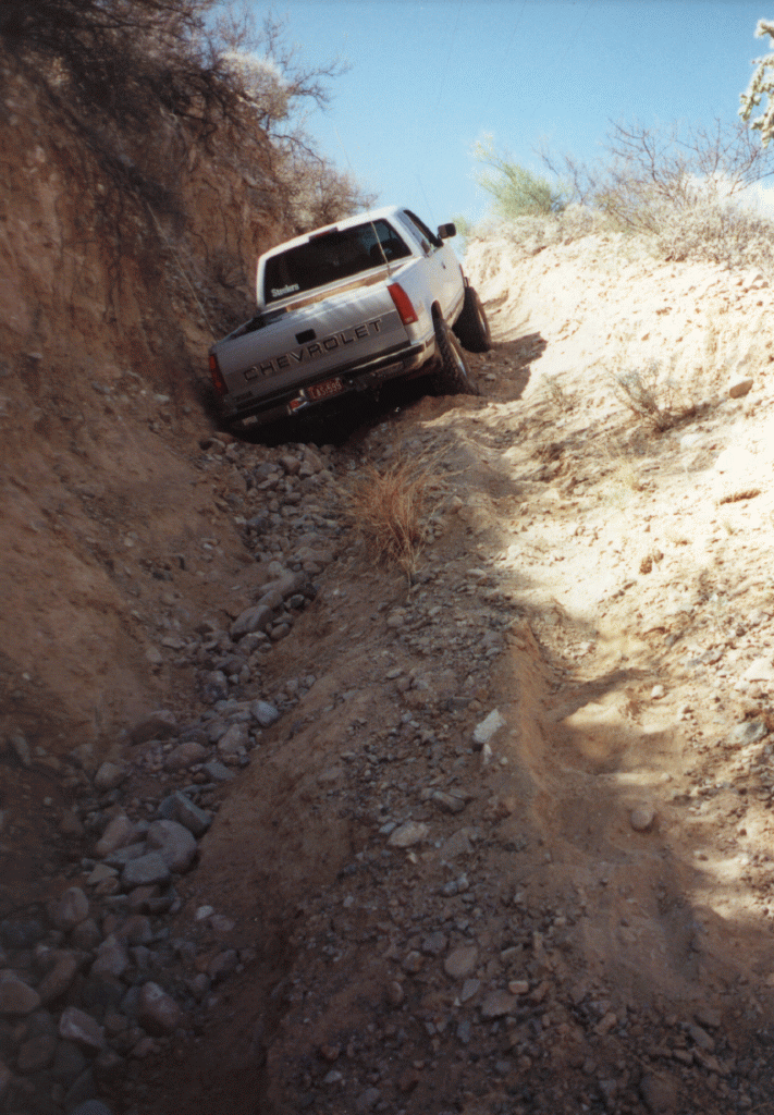
On Friday afternoon April 18, after a machaca burro at Micha's, John Hill, Bob Peterson and John Waack took their respective big Chevys down to the Green Valley Powerline Trail. This was the first run to test the new LockRight PowerTrax locker in the rear of J. Hill's Chevy pickup. We ran the powerline trail from south to north in order to hit the serious hill climbing early. My truck had previously done this trail south-north with only the factory Insta-Trac in the rear, but the LockRight made some of the hills easier. We also established again that the toughest hill going north-south is not climbable with only one locker. After doing all the hills on the southern third of the trail, we expected to cruise the rest of the way. Some erosion on the middle section of the trail had turned a tricky off-camber hill into a truck-swallowing gully. At this point, I was able to demonstrate that you can get stuck in nastier places with a locker. Both "The River...." and "Free Willy" had to be winched up through the gully. J. Waack's full-size Blazer with two lockers was able to climb it. We got back to pavement near Amado around sunset. Thanks to the washed out gully, all three trucks lost some paint high on the driver's rear fender.
Tucson Rough Riders Trip Report
Green Valley Powerline Trail
Saturday November 20, 1998
Trip Leaders: John Hill (a.k.a. The River...; w/o his truck) and Bob Peterson (a.k.a. Free Willy)
The weather was sunny with temperatures in the upper 70's -- an ideal day for wheelin'! We had 10 vehicles on this trip including small Chevys (S-10), medium Chevys (Blazer), big Chevys (Suburbans), small Jeeps (CJ/TJ), medium Jeeps (Cherokee), big Jeeps (3/4 ton P/U) and the odd Toyota, but not a Samurai nor a Ford in sight. We also had 17 people and 5 dogs.
We started on the easy end of the Green Valley Powerline trail running North to South from the Mt. Hopkins road. Less than a mile into the trail, an S-10 pickup dropped two wheels into a deep erosion gully on the SIDE of the trail. Who has that cowbell anyway? It took some digging plus two winches and two snatch blocks to extract him from this predicament.
The rest of the run provided a fun series of hill climbs and washouts. Neither the hunters nor the power company seem to be using the road very much, so it is ideally unmaintained for wheelin'. We stopped now and then for lunch, trail repair, unseated tires and vapor lock. By 4PM we had gone about 6 miles and arrived at the first hill where even one locker wasn't enough to power over the loose boulders. Only Snowball and Toolman were able to climb this one. Since it was late and we had several open diff vehicles, we decided to call it a day and exit on a ranch road that brought us out near Tubac.
We promise to have another run real soon that does the southern third of the trail starting near Tumacacori. That run will require at least one locker, as the hills are steeper and longer on the southern part of the trail.
About half the vehicles picked up some road rash to decorate their sheet metal, but there wasn't any major breakage. All the breakage occured on the (South-North) prerun the day before when Bob and John destroyed a Lock-Rite locker, a passenger window, a battery terminal and a CB antenna.
Wheelin' Trip Report
Green Valley Powerline Trail
Monday January 18, 1999
On Monday January 18, John Hill & John Waack in "The River...", Bob and Robbie Peterson in "Free Willy" and Scott "Popeye" & Denise Sides in their custom Cherokee took advantage of the nice weather to run the Green Valley Powerline trail.
Our intention was to run the more difficult southern section of the trail. This intention was deflected because the power company has done their trail maintenance and graded some really fine ruts into a nice drive in the country. Almost the whole trail is now a tame class 3 drive. There are still two challenging hills if you are going North-South. "One-Axle Hill" still requires at least one locker to climb it. The very steep hill near the southern end of the trail still needs two lockers. Popeye was able to climb it, and the rest of us used him as a winch point. We finished the whole length of the trail by 1PM (2.5 hours).
Next we went across I-19 in Tumacacori and spent the rest of the afternoon in Rock Corral Canyon. The uppermost part of the main canyon has been closed to trucks because of a 12-foot high boulder that has slid into the middle of the trail. Horses and ATV can still make it through.
The only thing approaching damage is that "Free Willy" needs a new transfer case.
John and Bob ran the Green Valley Powerline Trail on Saturday. It is in a fine state of erosion for an afternoon of wheelin' fun. Knowing the trail, and with each of us having a rear locker, we made the length of the trail in 3 hours. The northern 2/3 of the trail is currently rated a 3. The southern 1/3 is rated 3.5 with some steep loose climbs. The gate on Santa Gertrudis lane is locked so you have to access the south end via Rio Rico. For you hunters, we saw lots of quail in the section south of the Kantor sub-station. We had one winching and no vehicle damage.
The central third of the trail is also rated 3 -- the difficulty of the hill climbs increases. The major obstacles are erosion gulleys and hills covered with loose rock. Some places require taking the bypass roads.
The southern third of the trail is rated a 3.5 - 4 -- long steep hills make at least one locker essential, and it helps to have a friend with a winch.
To reach the south end of the trail, take I-19 exit 17 "Rio Rico"; go east 1 mile on Rio Rico Drive; go north about 6 miles on Pendleton Dr.; turn northeast on Camino Josefina. After a few miles, turn left on Amatista; another unmarked left turn gets you to the powerline. Beware that the transition from pavement to serious hill climbing is quite abrupt.
The trail is easy to follow because it runs mostly under the powerline. There are several places where the terrain makes it necessary to take a detour. Sometimes the bypass is easy to find, but in other places the route is fairly obscure. Several public roads and ranch roads intersect the trail along the way dividing it easily into thirds. The easier northern section ends at the old Mt. Hopkins road in Montosa Canyon. Some of the ranch roads are private so they should only be used for emergencies.
| Landmark | UTM Easting | UTM Northing | Altitude |
| I-19 exit 29 "Tumacacori" | 12 4 95 000 E | 34 91 878 N | +3328 |
| Camino Josefina at Pendleton | 12 4 96 765 E | 34 91 013 N | +3000 |
| Turn West from Camino Josefina at Amatista | 12 4 99 420 E | 34 93 555 N | +3521 |
| Southern Trailhead | 12 4 98 980 E | 34 93 940 N | +3394 |
| Montosa Canyon | 12 4 96 950 E | 35 07 010 N | +3240 |
| Northern Trailhead | 12 4 98 707 E | 35 09 792 N | +3240 |
| Mt. Hopkins Road at Elephant Head | 12 4 97 918 E | 35 11 340 N | +3100 |
| Elephant Head Road at frontage road | 12 4 95 811 E | 35 12 584 N | +3000 |
| I-19 exit 56 "Canoa" | 12 4 97 989 E | 35 17 135 N | +3373 |
Last modified: Mon Oct 21 12:21:50 2002